|
Attempt to investigate the future of KL Auschwitz (the Stammlager) as it was being planned in 1941 and 1942
|
The protective custody camp, later concentration camp at Oswiecim (Auschwitz) was to be part of the development of a German settlement or colony [Siedlung] in this region that the Nazis considered to be too Polish. Before the order to exterminate the Jews arrived and radically changed the face of the camp, the Bauleitung was asked to draw up development plans which were intended to he an “SS model” for the Eastern Marches.
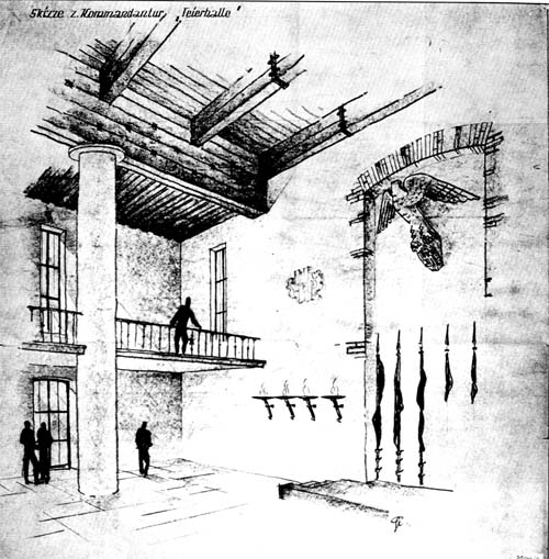
This project was considered so important that architects came from Berlin to work on the spot. The style, quality and power of the buildings envisaged are perfectly reflected in the artist’s impression of the “Ceremonial Hall” of the New Headquarters [Kommandantur] at Auschwitz [Document 1]. The grandiose structures of the SS builders were intended to last a thousand years.
The development plan for the town of Auschwitz had three main components: |
| 1. |
Extension and reorganization of the concentration camp, a pool of labor, based on the old Polish barracks and the creation of a monumental SS complex with adjoining family quarters to the north. An industrial zone was to flank the camp on the west, [Document 3 is the overall plan of the project. Documents 1 and 2 are artists' impressions of the interior of the New Garrison Headquarters and Documents 4 to to 10 are elevations and plan drawings of the SS accommodation in the northern part of the garrison area]. |
| 2. |
Reorganization of the town of Auschwitz and of its center, designed as a military and industrial city. To the east is the vital link between the city and the outside world, the railway station. The concentration camp, is located in the Zasole district, between the station, the river Sola and the old town, but for the SS it was not to belong to the city of Auschwitz. being territorially, administratively and legally distinct from it. It was simply to be a “highly concentrated” working class suburb. There were to be three German residential districts centered on the old town: Blonie (to the cast), Dwory (to the west) and Osiedle (to the south). The number of bridges across the Sola (to the east) and the Vistula (to the north) was to be eight times the prewar figure [Document 11, development plan for the Auschwitz region: Document 12, development plan for the town of Auschwitz; Document 13, Nazi Party community center, its precise location not known, but somehow here near the IG Farbenindustrie zone; Document 14, plan of the forum of the new city, eastern district; Document 15, model of the proposed redevelopment of the old town; Document 16, partial view of a model of a housing estate, probably in the southern district of the city).
Paradoxically enough, the development plans for the town of Auschwitz produced in September-October 1942 were considered “secret” whereas the project for a crematorium in January 1942 was not. The January drawings, however, concerned a perfectly normal cremation installation whose existence could be revealed, though when its conversion to a criminal instrument was envisaged the situation changed. On the other hand, the development plans, and hence the drawings, for the town of Auschwitz were directly connected with the German war effort and the presence of a vital component: a synthetic fuel plant. From the standpoint of the conflict in progress, knowledge by the Allies of German industrial projects in the Auschwitz area would have been more valuable than the plans of buildings that resembled bakeries. |
| 3. |
Installation at Monowitz of a huge industrial complex by IG Farbenindustrie, producing sythetic fuel (methanol) and synthetic rubber (the Buna plant). This industrial center was located on the Silesian coal basin and used coal as its raw material. The engineers and technicians were to be Germans or nationals of other Axis countries, semi-skilled workers would be supplied by compulsory labor schemes in the occupied countries and unskilled workers would he prisoners of war and internees from the camp
Other industrial zones were to be established around the giant IG Farben complex: two south of the camp: one northwest of the station and one north of Dwory. The industrial strip to the south of the camp and the Monowitz complex were the only ones actually built. |
|
| |
 |
|
| |
Document 1
[PMO neg. no. 20944/2] |
|
| |
Skizze z. Kommandantur “Feierhalle”
Sketch for the “Ceremonial Hall” of the garrison headquarters
The sketch is dated 1942, but the artist’s initials are not known. The sketch shows the interior of the hall in the main building of the new headquarters, but it cannot be located exactly because we have no detailed drawing of BW/Worksite 173. of which Documents 1 and 2 are the only known illustrations of the interior arrangements. |
|
|

